1 Mayıs 2013 Çarşamba

The Connected City Design Challenge, Dallas USA


Dallas’ key urban assets, Downtown and the Trinity River, are experiencing rebirth and rejuvenation, lifting the city’s quality of life and sense of place. Downtown Dallas is emerging as a vibrant collection of neighborhoods, and the Trinity River Corridor is transforming from floodway to public space. Existing patterns between downtown and the river offer no natural or inviting way of connecting Downtown to the planned Trinity River Corridor Park. 

The existing conditions between downtown and our river are the result of a collection of independent infrastructure and development decisions made over the past century. Priorities for needed flood control and regional mobility have built a physical condition presenting a challenge to advancing the future priority of connecting these two urban assets. 

The Connected City Design Challenge seeks bold design solutions connecting our Downtown and Trinity River overcoming the physical, psychological, and economic divide existing today. We are poised to realize a truly connected and livable future.

24 Kasım 2011 Perşembe

A New TAHRIR SQUARE Cairo, Egypt

The Rebirth of a Great Nation

    
an ideas competition where Revolution starts...   

  
Mısır özgürlük, barış, demokrasi ve adalet için bir savaş vermektedir. Bu savaş, halkının bir mücadelesidir. Bu mücadele yıllardır süren ve halen devam eden bir devrimdir. Bu devrim, geleceğin modern Mısır’ını kuracaktır. Milyonlarca insanın ülkeleri için toplandığı yer olan Tahrir Meydanı, kimi zaman kanlı gösterilere kimi zaman ise çadırlarında haftalarca yaşayan göstericilere ve mücadelecilere ev sahipliği yapmıştır. Bu meydan tüm devrim hareketinin başladığı yer olarak bilinmekte ve tüm dünyadaki devrimcilere de ilham kaynağı olmuştur.


Bu yarışma, bu meydanın Mısır Devrimi için üstlendiği misyonunu, tarihteki önemini ve gelecek kuşaklara bu değerlerini aktarabilmeyi amaçlamaktadır. Bu bağlamda, meydanın görselliğini kuvvetlendirmekle beraber çevresinin silueti bozulmamaya çalışılmıştır. Meydandaki boşluk ve açıklık hissi kısmen korunmuş, ancak bu tanımsız alana yeni bir fonksiyon da getirerek daha yaşanabilir kılınmaya çalışılmıştır. Ana aksların meydana doğru ulaştığı noktalarda, insanları meydanın içine çeken üç duvar, açık sergi alanları ve görsel enstalasyon alanı olarak tasarlanmıştır. Bu alan tarihin yaşatılmasında büyük rol oynayacaktır. Bu alanı karşılayan geniş kent basamakları insanları içine çeken özellikte olup asıl iç avluya ve şeffaf yapıya yönlendirmektedir. Bu avlu insanların buluştuğu bir noktadan ibaret olmayıp açık bir fuaye görevini de görebilir. Mavi şeffaf cam yapı, kapalı sergi alanı olarak düşünülüp, farklı ihtiyaçlara da cevap verebilecek fonksiyonları barındıran hafif bir yapıdır. Yapıyı örten yedi uçan platform aynı zamanda iç avluda ve yapının içersinde görsel doğal ışık ve gölge oyunlarına imkân kılabilmektedir. Bu yapı meydana gelip çadırlarda kalan insanları yine kucaklayan ve onları içinde barındıran bir özelliğe de sahiptir. İç avludan göğe yükselen ışık, Mısır kentinin ve Mısır devriminin yeni simgesi olacak, yeniden tasarlanan ve yeni fonksiyonlar da verilen bu meydan, geleceğin Mısır’ına bir ışık tutacaktır.
     

18 Eylül 2011 Pazar

Pruitt-Igoe Now Ideas Competition St. Louis Missouri


modern mimarlığın öldüğü bir bölgede bir yarışma...


an ideas competition in an area where modern architecture died...


trailer for the documentary film by Chad Freidrichs

Modern mimarlığın ilk öldüğü bir bölge olarak tanılan bu toplu konut alanı, 1950’li yıllarda A.B.D.’nin St. Louis, Missouri kentinde farklı sınıf insanlar için kurulmuştu. İlk başlarda insanlara için çok cazip halde olan bu yapı blokları daha sonraları, aşırı yoksulluk, suç oranlarının artışı ve ırkçılık gibi ciddi problemlerle yaşanmaz bir hal aldı ve bu yapı bloklarının yıkımı 1970’li yılların başında gerçekleşti. Bu tarih modern mimarlığın öldüğü gün ve post modern mimarlığın başlangıcı olarak yorumlanır. Açılan bu yarışmada bu alanın tekrardan tanımlanması, yeni bir program getirilerek ayağa kalkması amaçlanmıştır. Hazırlanan projede Pruitt Igoe izlerini günümüze taşımaya çalışılmıştır, Alandaki önemli izlerin korunması ile beraber, karakteristik kaldırımlar, Dickson caddesi ve diğer önemli yapılar korunmaya çalışılmış, bölgede sergi-konser alanları, yeni kent meydanı, gözlem kulesi, restoran kafe bar alanları, alışveriş market dükkanlar, spor ve rekreasyon alanları tasarlanarak yeni fonksiyonlar getirilmiştir. Böylelikle bölgenin insanları ve ziyaretçileri tarafından daha yaşanılır bir hal alması ve tarihi izlerinin hatırlanması sağlanılmaya çalışılmıştır.


18 Aralık 2010 Cumartesi

design of place Lalla Yeddouna in Fez , MOROCCO

explanatory report
                                              
The city Fez is the cultural and intellectual center of the country, Morocco. The city consists of two parts, the old city, Medina and the new French colonial city, Ville Nouvelle.
The Place Lalla Yeddouna is at the nucleus of the old city Fez. This place plays an important role in connecting the two banks of Fez River and so the two sides of the old city with the historical Bin Lamdoun Bridge.

competition site

The Place Lalla Yeddouna is a center for traditional handicraft as copper, brass smiths and tanners. But the craftsmen work in bad and inadequate places and this hinders the development and trade of the handicrafts. This negative situation affects the tourism and national income. The project competition focuses on the solution of this situation.
The area Place Lalla Yeddouna must be a healthy complex and a center for the production and a market for trading the handicrafts to the tourists and for the citizens.

                                                                                  fez

This place has to be a valuable artisan development and touristic center for the city Fez with its functional open and closed spaces as residences, production workshops, restaurants, cafes and other services.
The Place Yeddouna is now a lost square that needs to be arised with interventions. In the place there is an old fountain near by the historical building named Fondouk Lahssair. Around the place, there are other historical buildings, a mulberry tree that need to be preserved and restored. Besides this, the design of new buildings is required to receive the needs of the new functions and services.

river fez

place lalla yeddouna and the mulberry tree

The designed project aims to arise the square, The Place Lalla Yeddouna and create a functional, aesthetical complex around the river Fez. In order to achieve this, the characteristics of the topography are carefully taken under consideration to harmonize the natural environment and land. The layout and design of the buildings are done according to this idea.
In the designed project, there is an axis that starts from the fountain and reaches the bridge. This axis and the topographic character of the area form an imaginary layout circle. This layout circle gives the shapes and character of the new Place
Lalla Yeddouna Square
and the buildings. Therefore, the buildings have different altitudes with stepped heights that open the square’s front side.

   aerial plan


integration & layout concept
rehabilitation of existing structures

This imaginary axis and the layout circle play an important role in arising the square, the mulberry tree and the historical buildings so that the square can be perceived from the Bin Lamdoun Bridge. The new square connects the two sides of the city and becomes a new, valuable and attractive nucleus for the tourists and citizens. This is the main idea of this project.
The project area is divided into three areas: Zone 1, Zone 2 and Zone 3.
The buildings in Zone 1 have historical values and they have to be protected. In this area the buildings serve as retail shops, production-educational workshops, exhibition areas and family apartments.
The building Fondouk Lahssair is chosen in this project to be restored. The structural elements are reinforced. The other architectural elements like doors, windows, staircases are restored. The wooden elements like guard rails in the courtyard and the finishing materials on the floors and walls are restored to their original conditions.

utilization and circulation concept
design of a new building

The building consists of production workshop areas, restrooms on each floor and a meeting room for the craftsmen and trade people interested in. The connection of the building to the square is strengthened and a good communication is achieved with the ground floor workshops and exterior areas. So the building can take the visitors’ attraction and welcome them.
The narrow street, Bab Nooba becomes an attractive shopping distinct with its original atmosphere and opening to the hotel and restaurant area.
There is an other narrow street opening to the square on the north side of the area. This street connects the Bin Lamdoun parking area to the Place Lalla Yeddouna. But the street is disturbed and closed with unnecessary ruins. This street is called Bab el Courna. This new passage is redesigned and formed the curved design of the new building in Zone 2.
The new designed building in Zone 2 consists of ground floor retail shops, workshops and exhibition-stores with other service spaces. The ground floor retail shops facing towards, Bab el Courna passage plays an important role for this new passage to become an attractive shopping distinct. Bab el Courna also connects the parking area to the Place Lalla Yeddouna square, that the most important idea of this new settlement is.
One other important point in the area and also in the buildings is the carefully designed accessibility for disabled people with the help of ramps.
On the southern hand side of the square, in Zone 2, there is a comfort hotel for visitors and tourists. The hotel complex is designed according to the imaginary layout circle. This hotel complex has restaurants facing towards the mulberry tree and the square which gives a relaxing feeling to the visitors at day and night.
The other bank of the river Fez is Zone 3. This area is redesigned and some historical buildings are restored. The new buildings are designed adjacent to the historical ones with harmony. The main functions of the buildings located in this area are, exhibition-stores, retail shops, restaurants and cafes. Besides these functions, an information center for the coming visitors is located at a historical building which is restored.
The buildings located in the Zone 3 area have a Place Lalla Yeddouna square view. The area is connected to the left side of the river and enriched with open exhibition areas where visible accessibility and perception is achieved with the historical bridge Bin Lamdoun.
The interconnection zone B is considered as a green area and recreational park which is easily accessible from Derb Bin Lamdoun Street. Different recreational activities can take place in this area for the tourists.
The area has an inspiring atmosphere and is like an open museum of Arabic, Moroccan culture and architecture. So, in the restoration and designing the new buildings, same and similar local construction materials are used carefully in order to achieve the harmony and balance with the historical area and surrounding buildings. Further detailed surveys and studies must be done urgently to preserve and restore the area.
The long-lasting project aims to restore, preserve and develop the area in every point. This project is just the first step to achieve this. Besides architectural interventions, educational and commercial activities must be done to develop the traditional handicrafts and leave it to the next generations.
The area Place Lalla Yeddouna will be a useful complex and a center for the production and a commercial market for trading the handicrafts to the tourists and for the citizens.

H.Onur Dinmez  (november 2010)

5 Kasım 2010 Cuma

a new building in New York City

PEACE PENTAGON – A CALL TO ACTION

Friends of 339 invites architects, designers, artists, engineers and multi-disciplinary teams worldwide to participate in a competition to re-imagine and rebuild the Peace Pentagon, located at 339 Lafayette Street in New York City. This is an opportunity to give a physical form to a name in-use since this building became the center of peace-promoting activism in the 1960’s. We are seeking proposals that will support and expand the work of peace activists on several scales: as a financially and ecologically sustainable building, as a means of engaging with a neighborhood that has a rich history of activism and art, and as part of an influential city that can impact thinking in far away places.
The 339 Building Community originally formed around a shared office in Lower Manhattan, which was re-located to the present site in 1969. The building is owned by the A.J Muste Memorial Institute. Part of the Muste Institute's mission as a non-profit, is to provide low-cost space for a group of affiliated organizations, especially the original owner of the building, the War Resisters League. The 1st floor is currently rented to for-profit retail spaces and the two upper floors provide office space for peace and justice organizations at subsidized rents.

The Peace Pentagon Competition is a project for a living community and has been shaped by its need to balance limited resources, values, and priorities, while developing a vision for the future. One of the difficulties facing the building's owners is understanding the cost of changes in relation to available resources and potential benefits. Certainly, if a minimum repair scheme is the only way for the building to remain a peace and justice center, then this is the best option. But a vision for the future means asking how the building can best meet the needs of its users in a dynamic way. A minimum repair scheme will require a large financial investment, but will not provide many improvements to the specific program of this building
This competition requests the competitors to explore one of two alternatives: A new building or a renovation of the existing building.


ARCHITECTURAL REPORT

The five storeys Peace Pentagon building has an atrium which daylight goes through floors to save electricity. Atrium, located on second floor, provides natural ventilation with trees and freshness through building.
Building can be seen at distance from several points and by people using Bleecker Station. Building has a transparent glass facade which interacts with public. Citizens and passersby know what’s going on inside building. Facade is a good wall to communicate with world through organisations’ posters. So building associates with neighborhood promote a sense of community and raise public awareness about Peace Pentagon. Through façade spaces get daylight to save electricity.


Basement floor consists of pantry, maintenance and mechanical room. First floor is for retail space for supporting building financially and can be divided into five spaces. Second and third floors provide offices for organizations having daylight coming through atrium and glass facades. Fourth floor consists of a conference room, meeting space and library for tenants and public. The conference room can be used as a cinema room for extra income. Fifth floor is a social center for tenants, public and consists of restaurant, lounge, TV&game room and an exhibition hall having daylight from roof. The green roof has a café, meeting place and gives a chance for organizations and public to relax and enjoy their time in garden peacefully. Solar panel located at roof creates sustainable energy for space and water heating.
Spaces and shared program elements on floors that can be used by citizens, provide income. The organizations and public get together with activities that deepen a sense of internal community.
This concept strengthens the idea of being a symbol and a center of peace activism in NYC where different organizations get together, contact, promote a sense of community with neighborhood and raise public awareness about Peace Pentagon. This concept creates a vision for building’s future and a dynamic solution in a financial, ecological and practical way.

H.Onur Dinmez (november 2009)


GÜN IŞIĞINA ÇIKAN TARİH


Yarışma Hakkında

‘ İnsanların çevresi ile uyum ve denge içinde olması felsefesine dayanan akupunktur gibi, mimarlık da kentlerde yaşayan insanların yaşam koşullarını iyileştirecek ve sıradan olmayan eylemlerin başlatılmasını olanaklı kılabilmelidir. ’

‘ Akupunkturun ana ilkesinde olduğu gibi, bu eylem alanları basit ve etkisi hemen görülebilir türden, maliyetleri ise makul düzeylerde olmalı, kentlilerin günlük yaşamlarını kolaylaştırabilecek herhangi bir alana uygulanabilmeli, acil ihtiyaçlara cevap verebilmeli ve uzun vadede kentsel gelişime katkıda bulunmalıdır. ’

Dünyadaki tüm mimarlara ve mimarlık öğrencilerine açık, UIA kapsamında ve Celebration of Cities-3 , Maxmix Cities 3 adı altında üçüncüsü gerçekleştirilen bu yarışma da, katılanların yaşadıkları şehir ile ilgili gerçekleştirmek istedikleri bir hayallerini sunmaları istenilmektedir. Bu seneki yarışmanın ana fikrini ‘Maxmix’ kavramı oluşturmaktadır. Bu kavram; kentin sürdürülebilirliği için, yeni bir yaklaşıma ihtiyaç duyduğunu ifade etmekte ve bunu da geçmiş günümüz ve gelecek arasında kurulacak bağ ile yaratılacak değer tarafından sağlanabileceğini öngörmektedir. Bu bağlamda; “Maxmix” kavramı farklı alanlardaki dinamiklerin değişimi ve karışımıyla kentte yeni bir düzen kurma sürecini ifade etmekte ve kent içeriğinin çeşitli hale gelerek kent için yeni bir değer yaratma potansiyelini ifade etmektedir.


Kentin Tarihi Geçmişi ve Mevcut Sorun

‘M.Ö. 3000 yıllarında Bayraklı-Tepekule’de kurulan, bir liman kent ve ticaret merkezi olan İzmir-Smyrna, Pers istilasindan sonra Büyük İskender tarafından M.Ö.4.yy.da Pagos Dağı (Kadifekale) eteklerinde ve doğal liman arasında yeniden kurulmuştur. Yeni kent Kadifekale yamaçlarından, denize doğru uzanmaktaydı. Kentin varlığı deniz ticaretiyle yakından ilgiliydi. Çünkü kentin konumlandığı alan, Kadifekale'nin bulunduğu yer ile küçük bir koydan oluşan ve kenti gelecekte de şekillendirecek doğal bir liman arasında bulunuyordu. Bu doğal limanın etrafını dolaşan kavis, günümüzdeki Tarihi Kemeraltı çarşısının ana caddesini oluşturmaktadır. Kemeraltı Çarşısı, Mezarlıkbaşı semtinden Konak Meydanı’na kadar uzanan bölgeyi içine alan tarihi bir çarşıdır. Çarşının bugün ana caddesini oluşturan Anafartalar Caddesi, geniş bir kavis çizer. Yapıldığı ilk yıllarda çarşı, kısmen tonozlu, kiremit örtülü, yan sokakları ve arastalarıyla bir kapalı çarşı görünümündeydi. Çarşı, Kemeraltı adını bu bölümlerin üstünün kapalı olmasından almaktadır.
İskender’in kurduğu bu kent, daha sonra Roma topraklarının bir parçası olup ilerleyen zaman içersinde 1071 yılında Türklerin Anadolu’ya girmesiyle Türk egemenliğine girmiştir. Haçlı seferlerinden sonra Venedik ve Cenevizlilerin eline geçen kentte her geçen gün ticaret gelişmiştir. Türkler azınlık olarak Pagos Dağı’nın zirvesindeki Kadifekale’de kalmışlardır. Böylelikle şehir yukarıda Türk İzmir, aşağıda Hıristiyan İzmir olmak üzere ikiye bölünmüştür.
1426 yılında Osmanlı egemenliğine geçen şehir, tepedeki yerleşim yerleri ile liman birleşmiş ve buralarda da Müslüman nüfusun artmasını sağlamışlardır. Gelişen ticaret ile İngiliz, Fransız ve Hollandalılar şehre gelmiş ve İzmir, Doğu Akdeniz’in en önemli liman kentlerinden biri haline gelmiştir. 1838 yılında Osmanlı Devleti ile İngiltere arasında imzalanan serbest ticaret antlaşmasıyla, İmparatorlukta yabancılara ticaret yapma hakkının tanınmasıyla, Sakız Adası'nda ticaretle uğraşanlar İzmir'e gelip, yerleşmeye başladılar. Böylece İzmir, Batılı devletlerle olan ticari hacmine paralel olarak 1.Dünya Savaşına kadar sürecek büyük bir gelişim ve dönüşüm içine girmiştir. Bu savaş ile Yunan işgali altına giren kent, Sevr Antlaşması ile Yunanistan’a bağlanması öngörülmüştür. Bu işgale karşı Türk ulusal direniş hareketi başlamış, 9 Eylül 1922’de Türk Ordusunun İzmir’e gelmesi ile Yunan İşgali sona ermiştir. Dört gün sonra, 13 Eylül 1922 sabahı İzmir’de büyük bir yangın başlar ve tüm kenti çok kısa bir sürede sarar. Bu felaketten sonra İzmir, tekrardan ayakları üstünde durmaya çalışır.
Halen önemli bir ticari ve turistik merkez olan İzmir, tarihi ve kültürel zenginlikleri ile ön plana çıkmaktadır. İzmir; su kemerleri, stadyumu, antik tiyatrosu ve tarihi antik agorası ile gelişmiş, düzenli bir kent olarak imar edilmiştir. Ticaretin, sanatın, felsefenin yoğunlaştığı, politik toplantıların ve seçimlerin yapıldığı, anıtlar ve heykellerin bulunduğu Smyrna’nın merkezi olan Agora, M.S. 178 yılında depremle yıkıldıktan sonra Marcus Aurelius ve eşi Faustina tarafından yeniden inşa edilmiştir.
İzmir Agorası, Hippodamos şehir planına göre merkeze yakın bir yerde kurulmuştur. Üç kat halinde inşa edilen agora, İon agoralarının en büyüğü ve en iyi korunmuş olanıdır. İzmir agorasının, dikdörtgen formda, ortada geniş (120 x 180 m) bir avlu etrafında sütun ve kemerler üzerine inşa edilmiş üç katlı stoa ve önünde merdiveni olan bileşik bir yapı olduğu anlaşılmıştır. İzmir Agora’sı, Antik çağdan günümüze kadar gelebilen nadir yapılardan biridir. Günümüzde de halen üniversite, belediye ve oda kuruluşları ile ortak düzenlenen çalışmalarla Agora kazı alanı genişletilmekte ve eldeki imkânlar doğrultusunda Agora gün ışığına çıkartılmaya çalışılmaktadır.
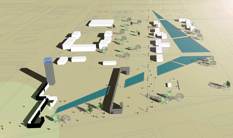
vaziyet planı

önerilen yeni meydan
  
Günümüz kent merkezi Konak Meydanı’ndan başlayan, Kemeraltı boyunca uzanan ve Agora ile buluşan tarihi bir aks ortaya çıkmaktadır. Bu tarihi aks boyunca, çeşitli alışveriş merkezleri, çarşılar, bedestenler, camiler ve tarihi özelliklere sahip yapılar bulunmaktadır. Bu aksı takip ettiğinizde İzmir’in tarihsel sürecini ve gelişimini izleyebilirsiniz. Bu aks yeniden düzenlenip İzmir’e kazandırılan Konak Meydanı ile başlamaktadır. Aks, Kemeraltı boyunca uzanan kıvrımlı Anafartalar Caddesi’ne giriş ile devam edip, bu cadde boyunca devam etmektedir. Tarihi Sinagog ve havraların bulunduğu ve günümüzdeki en hareketli alışveriş ve pazar sokaklarından biri olan Havra Sokağı ile kesişen aks, Namazgah’da bulunan ve İkiçeşmelik Caddesi tarafından önü kapanan tarihi antik Agora’ya çıkmaktadır. Ancak Agora’nın önünü kapatan ve algılanmasını engelleyen niteliksiz yapılaşma, kaldırımlara kadar taşan eski işyerleri ve yoğun araç trafikli İkiçeşmelik Caddesi bu aksın ortaya çıkmasına engel olmakta ve Agora’nın kentli tarafından algılanmasını büyük ölçüde engellemektedir. Belediyece yapılan kamulaştırma ve yıkım çalışmaları ile agora’nın ortaya çıkarılmasına çalışılmaktadır ancak sadece bu müdahele yeterli değildir. Bu çalışmanın yanında, bölgenin ortaya çıkarılabilmesi için araç yoğun trafikten uzak, yaya odaklı kentsel ölçeklerde müdaheleler gerekmektedir.

yıkım alanı


önerilen yeni düzenleme

Öneri

Burada; akupunktur ilkesinde olduğu gibi basit, etkisi hemen görülebilir, maliyeti makul, yaşamı kolaylaştırabilecek kentin kültürüne, turizmine, ekonomisine ve ulaşımına katkıda bulunacak noktasal müdahaleler yapılmalıdır.
Bu aksı ortaya çıkarabilmek için, Agora önündeki yapılaşmayı kaldırmak, bölgeyi bölen caddeyi yeraltına alarak bu aksı bütünleştirecek ve Agora’yı kentliyle buluşturacak yeni bir kent meydanı gerçekleştirilmelidir. Bu meydan, farklı aktivitelerin buluştuğu, tarihimizi, kültür çeşitliliğimizi yansıtan, geçmiş-günümüz-gelecek arasında tüm zamanların değerlerinin, dinamiklerinin ve işlevlerinin harmanlanacağı ve gelecek nesillere aktarıldığı bir meydan olmalıdır. Bu meydan, antik agorayı insanlara tanıtan, anlatan ve o antik yılların içinde yaşatabilen öğelerle nitelendirilmelidir. Kurulan bu tarihi bağ ile gelecek nesiller İzmir kent tarihine daha yakın olacaktır, yaşadıkları kenti daha çok benimseyeceklerdir.

yeni vaziyet planı

Bu müdahele ile günümüz kent merkezi olan Konak Meydanı ile yeni antik kent merkezimiz Agora birleşecektir. Bu birleşme ile bu bölgedeki tüm tarihi özelliklere sahip nitelikli yapılar korunarak gelecek kuşaklara aktarılması sağlanacaktır. Ayrıca bu aks ve yaratılan bu meydan ile kentsel cazibe alanları artacak, turizme ve ekonomiye katkısı sayesinde, kentteki istihdam sorununa da bir ölçüde çözüm yaratılmaya çalışılacaktır. İkiçeşmelik Caddesi’nin yeraltına alınarak, bu alana bir meydan düzenlemesiyle de kent içi trafiğin azaltılmasında yardımcı olunacaktır.
Bölgede yapılacak noktasal ama büyük etkili düzenleme dalga dalga yayılacak ve kentin diğer alanlarına da ulaşacaktır. Bunun sağlanmasındaki en önemli faktörlerden birisi de ortaya çıkarılacak Agora ve kenti içindeki tarihi aksdır. Bu noktasal müdahele sadece kentsel ölçekli bir proje olmayıp, tarihi, mimari, ekonomik ve sosyal anlamda büyük kazanımları da vardır.

agora ve katlı otopark

Ikiçeşmelik caddesi ve katlı otopark
Sonuç

Müdahaleyle kentte yeni bir düzen oluşarak, içeriği çeşitlenecek ve içindeki etkileşimlerle yeni, sürdürülebilir bir değer yaratma ve kentsel gelişme potansiyeli oluşacaktır.
Bu gelişim, dalga dalga yayılacak ve yaşam koşullarının iyileşerek insanların çevresi ile uyum ve denge içinde yaşayacağı dinamik ve çekici bir kenti ve yeni kent meydanını hayata geçirecektir.

H.Onur Dinmez  (mayıs 2009)


ENGLISH SUMMARY

Izmir-Smyrna, a harbor city and a commercial center, was first settled in Bayrakli-Tepekule at A.D.3000. After Persian invasion, city was resettled by Spartacus between MountPagus (Kadifekale) and natural harbor at A.D.4th century. Curve which surrounds harbor, formed today’s Historical Kemeralti Avenue.

Izmir was reconstructed as an ordered, developed city with aqueducts, stadium, amphitheatre and Agora. Agora, center of Smyrna, was center of commercial activities, art, philosophy, political meetings and elections filled with sculptures, monuments and it was reconstructed by Marcus Aurelius and his wife Faustina after the earthquake in A.D.178.

There is a historical axis where starts at Konak City center, passes Kemeralti and meets Agora. But buildings in front of Agora and Ikicesmelik Avenue hinder the perception of Agora.

Like acupuncture principal, there has to be easy, effective, economic point interventions which contribute culture, tourism, economy and transportation of city.

To arise axis, we have to remove buildings in front of Agora, put avenue underground so axis will be whole and a new center will be established which meets Agora with city. This center will have different activities reflecting our history, culture and mixes the values, dynamics and functions of past-today-tomorrow and transfer to future generations.

With these interventions, there will be a new order in city, various content and influences; new, sustainable value and urban development potential will take form.

This development will spread, life standards will be better and there will be a new, dynamic and attractive city and center where people live in pertinence and balance.